
Sutjeska National Park: The Complete Visitor Guide to Bosnia's Oldest Wilderness
Perućica is not a rainforest. It's something rarer - a primary forest, ancient and untouched, one of the last of its kind in Europe. No cleared paths, no replanted trees. Just centuries of uninterrupted wild.We didn't find this place. We grew up in it. And now we want to show it to you.
Table of Contents
1. What Is Sutjeska National Park?
2. Getting In — Fees & Base
3. Perućica Primeval Forest & Skakavac Waterfall
4. Trnovačko Lake — The Heart-Shaped Glacier Lake
5. Via Ferrata Kuk — Bosnia's Best Beginner Ferrata
- How to Get There
- What to Expect on the Route
6. More to Explore in the Park
If you want specific tour this one is the best Perucica rainforest + Prijevor viewpoint Maglic mountain tour
What Is Sutjeska National Park?
Sutjeska is Bosnia and Herzegovina's oldest and largest national park, established in 1962 and covering 16,052 hectares of mountain wilderness in the southeastern corner of the country, on the border with Montenegro. Over 66% of the park is covered by forest, meadows and alpine pastures. It is bounded by the rivers Piva, Drina and the upper Neretva, and overlooked by a ring of serious mountain peaks — Maglić, Volujak, Bioč, Vučevo, Lebršnik and Zelengora. In 2000, IUCN classified it as a Category II protected area, one of the highest designations for natural value in the world. What makes Sutjeska genuinely different from every other national park in the region is density of experience. In one place you have one of Europe's last primeval forests, a chain of glacial lakes, the country's highest summit, a WWII memorial of international architectural significance, rivers cold enough to shock the system, and mountains that almost no one outside the Balkans has ever heard of. This is the park that gets called the "Yosemite of the Balkans" — a comparison that undersells it.
Note: The national park entry fee is 10 BAM / 5 EUR per person, collected at the checkpoint on the main road into the park. All fees in Sutjeska National Park are cash only — bring BAM or EUR in small denominations. There are no card payment facilities at any fee point inside the park.
Getting In — Fees & Base
The main base and starting point for all activities in Sutjeska is Tjentište - a small settlement in the heart of the park that houses the national park administration, the iconic WWII memorial complex, and the park's outdoor pool. Virtually every activity in this guide starts from Tjentište or passes through it. If you are staying overnight, this is where you base yourself. From Tjentište the park fans out in every direction. Perućica is a 30-minute drive. Trnovačko Lake is a one-hour drive to the Prijevor trailhead. Via Ferrata Kuk requires approximately 40 minutes to reach the turnoff from the main Foča–Gacko road. And the Tara River - the starting point for rafting - is around 40 minutes from the park in the direction of Foča. Plan your days accordingly: most activities take a full day, and trying to combine two in a single day is ambitious for most groups.
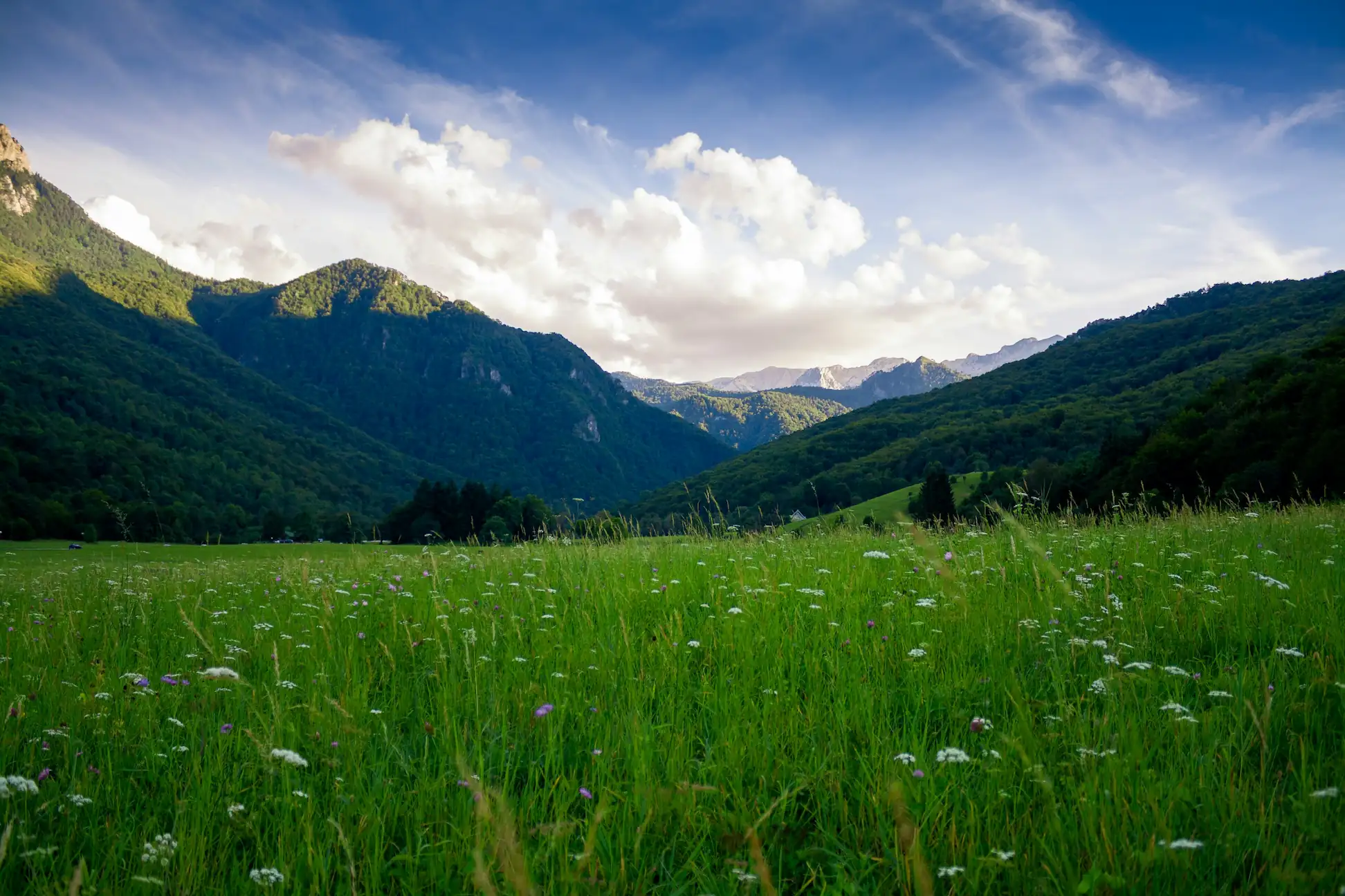
Perućica Primeval Forest & Skakavac Waterfall
Perućica is one of the last two primeval old-growth forests remaining in Europe — and one of the most misunderstood places in the park. It is frequently labelled a "rainforest" online, which is factually incorrect. A rainforest is a climate-defined ecosystem, typically tropical. Perućica is a primary old-growth forest — a forest that has never been logged, cleared, or disturbed by humans. That distinction is what makes it extraordinary. Some trees here are 57 metres tall and some specimens are over 300 years old. You cannot regenerate this in a human lifetime. Access is from a trailhead just above Dragoš Sedlo, roughly 30 minutes from Tjentište by road. The trail descends through dense forest — unmarked, steep in sections, and ending at Skakavac, a 70-metre waterfall at the bottom of the gorge. On the way back, stop at Beškita Viewpoint for the best panorama in the park: the full canopy of Perućica below you, Skakavac visible in the distance, Maglić above, and Tjentište directly opposite with the WWII memorial rising from the valley floor. Entry into Perućica is strictly guided — independent access is prohibited by national park regulation, no exceptions.
Trnovačko Lake — The Heart-Shaped Glacier Lake
Trnovačko Lake sits at 1,517 metres on the Bosnia–Montenegro border, directly beneath the ridge of Maglić. It is a glacial lake in a near-perfect heart shape, with blue-green water that reaches 17–20°C+ in July, August and early September — warm enough to swim in. A local ranger is stationed at the lake during season and sells cold drinks and beers, which after a two-hour mountain hike feels like one of the finer things in life. The trailhead is at Prijevor saddle, one hour by road from Tjentište, arriving via the national park entry checkpoint. From Prijevor the hike takes 1.5 to 2 hours one way, passing the rocky Špičar outcrop along the canyon rim, descending through Suva Jezerina — a dried glacial lake basin that no longer holds water due to climate change — and then through forest before dropping into the lake basin. A separate 1–2 EUR per person fee is collected at the lake by the Montenegrin ranger. The return follows the same path. A licensed guide is strongly recommended — the trail is not fully marked and conditions on open ridgelines can shift fast.
Via Ferrata Kuk — Bosnia's Best Beginner Ferrata
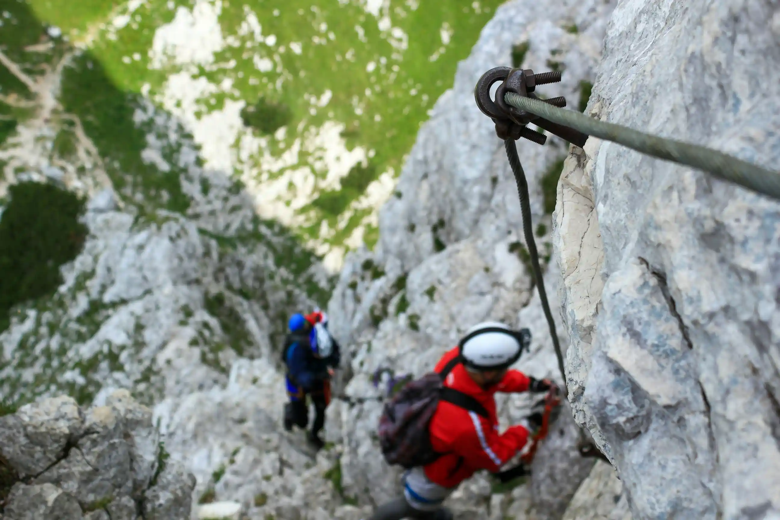
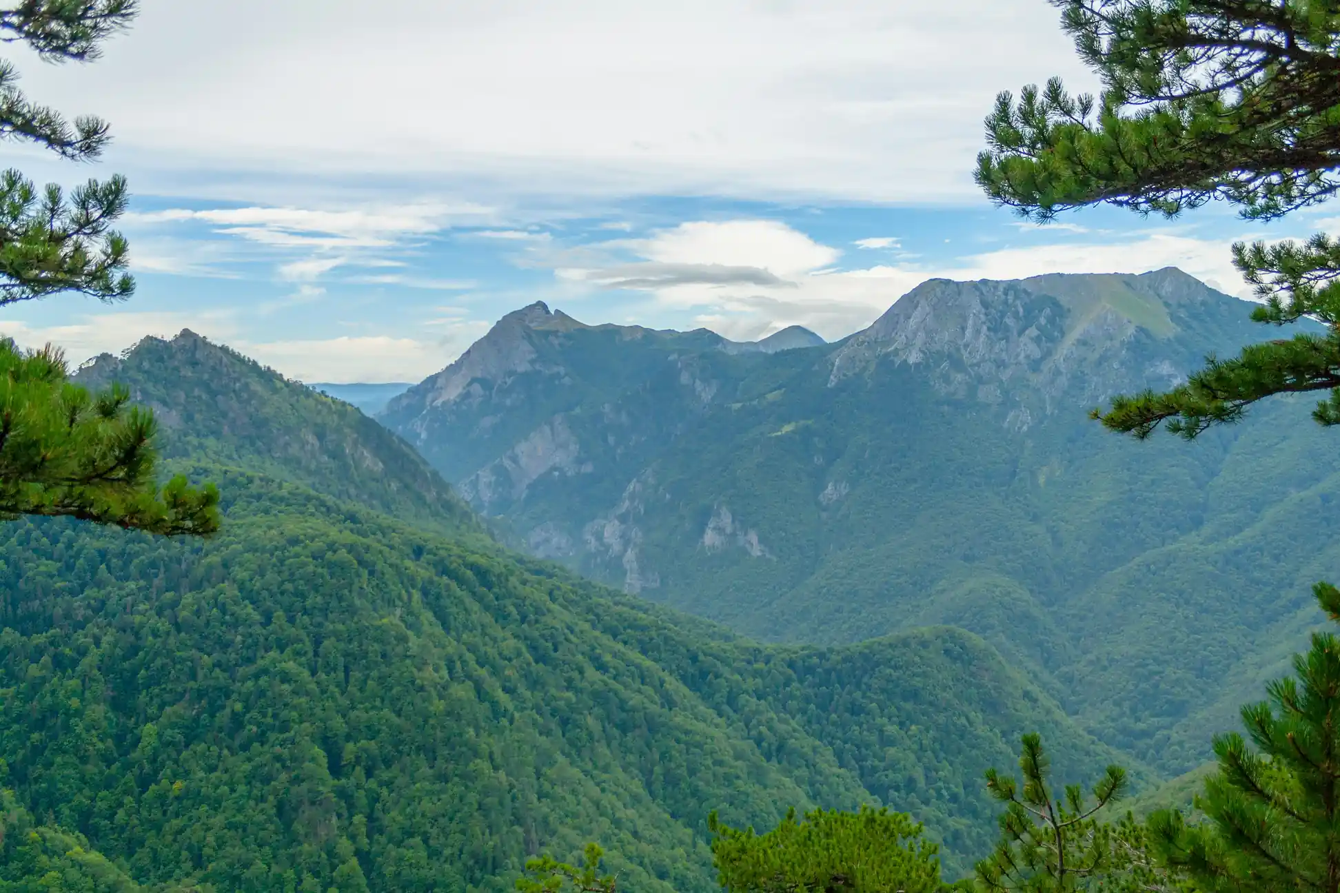
Via Ferrata Kuk is the newest via ferrata in Bosnia and Herzegovina and the best entry point into the sport for beginners. It sits above the Papin Do mountain lodge in the Volujak massif, with views across Volujak, Lebršnik and Zelengora that open up progressively as you climb. The ferrata is equipped with resting spots along the route so you can pause, breathe, and take in the surrounding peaks without pressure. It is the kind of route that shows people what via ferrata actually feels like — technical enough to be memorable, accessible enough not to be intimidating.
How to Get There
From the main Foča–Gacko road, turn off toward the village of Čemerno and follow the gravel road to Papin Do mountain lodge — approximately 8km of gravel road, accessible for all vehicles in summer months. From the lodge, continue 150 metres further along the gravel road and park on either side. Do not continue driving toward the mountain huts in the valley below Kuk unless you have a 4WD — it is not suitable for regular vehicles. From the lodge, follow the trail toward the summit of Bioč and turn right when you see the "winter" trail marker on your right. Follow the winter markers across the open meadow to the water spring and info board for the ferrata. From the info board, continue along the prepared trail over the scree field — clearly marked — to the ferrata entrance.
What to Expect on the Route
| | | | --------------------- | --------------------------------------------------- | | For whom | Physically fit individuals comfortable in mountains | | Approach to ferrata | ~80 minutes from lodge | | Ferrata length | 830m | | Elevation gain | 200m | | Technical difficulty | B/C | | Average crossing time | ~120 minutes | | Summit | Kuk plateau | After completing the ferrata you emerge onto the Kuk plateau. For the descent, follow the via normale trail for Kuk — it leads downhill over open terrain, then turns sharply right into beech forest at a point marked with a winter trail marker. A short section through the forest brings you down into the valley below Kuk and Jagodno Lake, from where the marked trail leads back to Papin Do lodge.